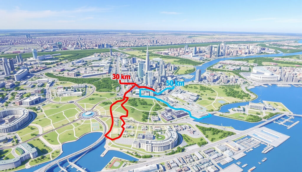
Tour de l’Île Montréal 2025 Map: 30 km & 50 km Routes
Every spring, Montreal’s car-free streets become a cyclist’s paradise. The Tour de l’Île de Montréal, now in its 40th edition, offers two routes through the east end of the island. On June 1, 2025, riders will conquer either a 30 km or 50 km course, with the longer route accumulating about 101 meters of elevation gain, according to official GPS data. Whether you’re a casual rider or a seasoned cyclist, the guide breaks down the map, logistics, and must-know details so you can ride with confidence.
Route distance: 30 km and 50 km options ·
Elevation gain (50 km): ~101 m ·
Event date: Sunday, June 1, 2025 ·
Start/Finish: Parc Maisonneuve ·
Car-free streets: Yes, entire route
Quick snapshot
- Date: June 1, 2025 (Vélo Québec Official PDF)
- Two routes: 30 km and 50 km (Vélo Québec Official PDF)
- Start at Parc Maisonneuve (Vélo Québec Official PDF)
- Entire route car-free (Vélo Québec Official PDF)
- Exact start time – not yet published (historically ~8:00 AM)
- Weather conditions on event day
- Final participant count (registration still open)
- Whether relay stations will have water refills
- If route may be adjusted last minute due to construction
- Spring 2025: Registration opens (Vélo Québec)
- Late May 2025: Route maps published on Ride with GPS and Vélo Québec (Ride with GPS)
- June 1, 2025: 40th edition (Sunday) (Vélo Québec Official PDF) (Vélo Québec)
- September 2026: Grands Prix Cyclistes de Montréal (pro race) (Nouvelles d’ici)
- Registration remains open – claim your spot via Vélo Québec website (Ville de Montréal-Est)
- Official route maps will appear on Ride with GPS and as PDF in late May (Ville de Montréal-Est)
- Check street closure notices (e.g., Montréal-Est from 9:45 AM to 3:15 PM) (Ville de Montréal-Est)
- After the ride: explore other Go Bike MTL festival events and prepare for 2026 Grands Prix (Ville de Montréal-Est)
The table below captures the core facts in one glance.
| Edition | 40th Nouvelles d’ici |
| Date | June 1, 2025 (Vélo Québec Official PDF) |
| Distances | 30 km and 50 km (Vélo Québec Official PDF) |
| Elevation (50 km) | ~101 m Ride with GPS |
| Start/Finish | Parc Maisonneuve, Montréal (Vélo Québec Official PDF) |
| Car-free | Yes, entire route (Vélo Québec Official PDF) |
| Organizer | Vélo Québec (Nouvelles d’ici) |
| Registration | Open on Vélo Québec website (Vélo Québec) |
How long is the Tour de l’Île de Montréal?
The 40th edition offers two distinct distances so riders can choose their comfort level. Both are fully car-free on June 1.
What is the distance of the 30 km route?
- The shorter loop covers approximately 30 km, staying mainly on residential streets through Rosemont and Hochelaga-Maisonneuve (Vélo Québec Official PDF).
- It is designed for families, casual cyclists, and anyone looking for a relaxed morning ride.
What is the distance of the 50 km route?
- The full parcours is 50 km, starting and ending at Parc Maisonneuve (Vélo Québec Official PDF).
- GPS data records the route at exactly 49.7 km (Ride with GPS).
What is the elevation gain for each option?
- The 50 km route has an elevation gain of about 101 meters, with a 2.2% average gradient and a maximum climb of 108 meters (Ride with GPS).
- The 30 km route is flatter, making it ideal for beginners.
The implication: even first-time participants can handle the elevation without specialized training.
What is the route map for the Tour de l’Île de Montréal 2025?
Knowing exactly where you’ll ride is half the preparation. The official map is available in multiple formats, and the path weaves through east-end neighbourhoods with several bridges and relay stops.
Where can I see the official route on Ride with GPS?
- The 50 km course has been uploaded to Ride with GPS with full turn-by-turn data (Ride with GPS).
- A 30 km version is expected to be published in late May 2025 on the same platform.
What neighborhoods does the route pass through?
- Rosemont, Hochelaga-Maisonneuve, Anjou, and Mercier are all on the itinerary (Vélo Québec Official PDF).
- Key streets include boul. Lacordaire, rue De Cadillac, boul. de l’Assomption, boul. Pie-IX, av. Bourbonnière, and rue Sherbrooke Est.
- Also: rue Pascal-Gagnon, boul. des Galeries d’Anjou, boul. Roi-René, av. Ozias-Leduc, boul. Rosemont, rue Viau, av. Rita-Levi-Montalcini, boul. Gouin Est, rue de Montigny, and rue René-Lévesque.
Does the route include any notable landmarks?
- Three bridges are crossed: Pont Olivier-Charbonneau (25 km), Pont Charles-de-Gaulle (40 km), and Pont-tunnel Louis-Hippolyte-La Fontaine (25 km) – all open to cyclists during the event (Vélo Québec Official PDF).
- Relay points are at 16 km (Parc Don-Bosco), 28 km (Relais 2), and 40 km (Vélo Québec Official PDF).
The route prioritizes residential and park connections over major highways, giving riders a safe, scenic tour of east Montreal’s diverse districts. The three bridges add a mild technical element without steep grades.
The pattern: riders get a suburban tour with three gentle bridge crossings that break up the flat terrain.
When and where does the Tour de l’Île de Montréal 2025 take place?
Mark your calendar and plan your arrival – the event has a fixed date and a central starting point, but the exact start time is still to be announced.
What is the exact date of the 2025 event?
- Sunday, June 1, 2025 (Vélo Québec Official PDF).
- The event runs from approximately 9:00 AM to 2:30 PM, per past editions (Nouvelles d’ici).
What time does the event start?
- The exact departure time has not been published for 2025 yet. Historically, riders start rolling around 8:00 AM.
- Check the official Vélo Québec page closer to the date for confirmation.
Where is the starting point located?
- Start and finish: Parc Maisonneuve, a large park in the Rosemont–La Petite-Patrie borough (Vélo Québec Official PDF).
- Street closures in Montréal-Est affect Dorchester, Broadway, Prince-Albert, Lesage, Notre-Dame, and Georges-V from 9:45 AM to 3:15 PM (Ville de Montréal-Est).
While the date is solid, the exact start time remains unconfirmed – anyone planning a tight schedule should watch the official site for updates, especially to avoid arriving late after morning road closures begin.
The upshot: riders should plan to arrive by 7:30 AM to allow for parking and number pickup, regardless of the official start.
Can you bike from Montreal to Quebec City?
The Tour de l’Île is a city ride, but many cyclists wonder about longer routes. Montreal to Quebec City is a classic multi-day tour with its own dedicated path.
What is the distance between Montreal and Quebec City?
- Approximately 250 km by road or bike path (Vélo Québec).
What is the best cycling route (e.g., King’s Road)?
- King’s Road (Route 138) is a popular option, offering a mix of bike paths and quiet roads along the St. Lawrence River.
- Vélo Québec recommends the Route Verte, which connects Montreal to Quebec City via a well-signed network of paths and country roads.
How long does it typically take to bike between the cities?
- Most cyclists plan for two to three days, with overnight stops in towns like Trois-Rivières or Saint-Augustin-de-Desmaures.
Compared to the Tour de l’Île’s one-day car-free loop, the Montreal-Quebec journey is a multi-day commitment on mixed-traffic roads. Choose the 50 km ride if you want a single-day challenge; pick the 250 km route if you are seeking a weekend adventure.
The key takeaway: the Tour de l’Île remains the most accessible way to ride car-free on a large scale inside the city.
What other cycling events are in Montreal?
The Tour de l’Île is just one part of Montreal’s vibrant cycling calendar. Two other major events stand out: the Grands Prix Cyclistes and the broader Go Bike MTL Festival.
What is the Grand Prix Cyclistes in September 2026?
- The Grands Prix Cyclistes de Montréal is a professional UCI World Tour race, separate from the Tour de l’Île participant ride (Nouvelles d’ici).
- It is scheduled for September 2026 and features elite men’s and women’s teams racing on a demanding circuit through Mount Royal.
Are there other festival rides during Go Bike MTL?
- Yes, Go Bike MTL Festival includes multiple rides: the Tour de la Ville (more challenging), the Tour la Nuit (evening ride), and family-friendly parades.
- All happen during the same first weekend of June, creating a full cycling festival atmosphere.
Where can I find a full calendar of Montreal cycling events?
- Visit the Vélo Québec website for the complete 2025 schedule (Vélo Québec).
What this means: cyclists can build a full weekend around the festival, from family rides to evening parades, all within the same weekend.
Event specifications
Eight key specs, one pattern: the 50 km route is meticulously measured and published – no guesswork for cyclists who love data.
| GPS distance (50 km) | 49.7 km (Ride with GPS) |
| Elevation gain | 101 m (Ride with GPS) |
| Average gradient | 2.2% (Ride with GPS) |
| Max climb | 108 m (Ride with GPS) |
| Max descent | -2.1% (Ride with GPS) |
| Bridges crossed | Pont Olivier-Charbonneau, Pont Charles-de-Gaulle, Pont-tunnel Louis-Hippolyte-La Fontaine (Vélo Québec Official PDF) |
| Relay stops | 16 km, 28 km, 40 km (Vélo Québec Official PDF) |
| Street closures in Montréal-Est | 9:45 AM – 3:15 PM on Dorchester, Broadway, Prince-Albert, Lesage, Notre-Dame, Georges-V (Ville de Montréal-Est) |
The official PDF and GPS data leave no room for surprises. Riders can preload the route on their devices and know exactly when to expect the only significant climbs (the bridge crossings at 25 km and 40 km).
The implication: the 101-meter elevation gain is so evenly spread that even beginners can maintain a steady pace.
Timeline
Spring 2025
Registration opens for Tour de l’Île de Montréal (Vélo Québec)
Late May 2025
Route maps published on Ride with GPS and Vélo Québec (Ride with GPS)
June 1, 2025 (Sunday)
40th Tour de l’Île de Montréal (Vélo Québec Official PDF)
September 2026
Grands Prix Cyclistes de Montréal (pro race) (Nouvelles d’ici)
The timeline shows a single-day event with a long lead-up. For riders who want to prepare, the spring registration window is the only deadline; the map will drop just days before the ride.
What this means: the onus is on riders to sign up early and watch for the late-May map release.
Confirmed facts
- Date: June 1, 2025 (Vélo Québec Official PDF)
- Two routes: 30 km and 50 km (Vélo Québec Official PDF)
- Start at Parc Maisonneuve (Vélo Québec Official PDF)
- Car-free streets (Vélo Québec Official PDF)
- Official map from Vélo Québec (Vélo Québec Official PDF)
What’s unclear
- Exact start time – not yet published
- Weather conditions on event day
- Final number of participants (registration still open)
- Whether relay stations will have water
- Potential last-minute route changes due to construction
“The main parcours is 50 km starting and ending at Parc Maisonneuve.”
— Vélo Québec Official PDF (Traffic Info Notice)
“GPS route data shows 49.7 km distance, 101m elevation gain, 2.2% average gradient, 108m max climb.”
— Ride with GPS route 50014167 (Official GPS Track)
For Montreal cyclists, the 2025 Tour de l’Île de Montréal is a rare chance to ride car-free through the city’s east end. With registration still open and the route now mapped, the only question left is whether you’ll choose the 30 km family-friendly loop or the 50 km challenge — but either way, you’ll experience the city as few do. Participants aiming for the longer route should preload the GPS track, practice on moderate hills, and arrive at Parc Maisonneuve by 8:00 AM, or risk missing the start.
For a complete overview of the 40th anniversary edition, including start times and registration, check out the Tour de lÎle 2025 details.
Frequently asked questions
How do I register for the Tour de l’Île de Montréal 2025?
Registration is open through the official Vélo Québec website (Vélo Québec). You will need to pick up a participant number before the ride.
Is there a fee to participate?
Yes, a registration fee applies. Check the Vélo Québec site for the current pricing and any early-bird discounts.
Can I ride with a child?
Absolutely. The 30 km route is designed for families and cyclists of all ages. Children must be safe on a bike and able to follow traffic rules, as the car-free route still has intersections managed by volunteers.
What should I bring on the ride?
Bring a roadworthy bike, a helmet, water, snacks, and a repair kit. The relay stations may offer water, but it’s wise to carry your own. A printed or downloaded map of the route (available on Ride with GPS) is also recommended.
Are e-bikes allowed?
E-bikes that comply with Quebec’s regulations (max 500W, speed limited to 32 km/h) are generally permitted. Check the event rules on Vélo Québec’s site for any specific restrictions.
Where can I park near Parc Maisonneuve?
Limited street parking is available around the park. Organizers encourage using public transit (Sherbrooke or Pie-IX metro stations) or biking to the start. Some surrounding streets may be closed, so arrive early.
Is the route accessible for handcycles?
The route is on paved streets with gentle gradients, making it suitable for handcycles and adaptive bikes. Contact Vélo Québec in advance to confirm any accessibility needs.
More related posts
 Shoppers Drug Mart Sarnia: Locations, Hours & Pharmacy Guide
 Nick Robinson Movies and TV Shows: Full Filmography
 Mini Split Heat Pump: Pros, Cons, Costs & Installation
 Salut Bonjour En Direct – Hosts Schedule Streaming Guide
 Things to Do in London Ontario – Attractions Parks Events
 Doug Ford Speed Cameras – Ontario Ban Status 2026
 William H. Macy: Age, Wife, Movies, Net Worth, Bio
 Albacete Balompié vs Real Madrid Lineups: Copa del Rey 2026